

Clouds are classified mainly by their appearance and altitude. The World Meteorological Organization (WMO) recognizes ten main types, grouped into four families based on height.
1. High Clouds (Above 20,000 ft) – เมฆสูง
- Cirrus (Ci) – Thin, wispy clouds. Usually a sign of fair weather but can indicate an approaching warm front.
- Cirrostratus (Cs) – Thin, veil-like clouds covering the sky, often producing a halo around the sun or moon.
- Cirrocumulus (Cc) – Small, white patches, often in ripples; sometimes called “mackerel sky.”
2. Middle Clouds (6,500 – 20,000 ft) – เมฆกลาง
- Altostratus (As) – Gray or bluish sheets covering the sky, often preceding continuous rain.
- Altocumulus (Ac) – White or gray patches forming layers or waves, can signal unsettled weather.
3. Low Clouds (Surface – 6,500 ft) – เมฆต่ำ
- Stratus (St) – Uniform gray clouds, covering the sky like a blanket; can bring drizzle or mist.
- Stratocumulus (Sc) – Low, lumpy clouds, often with breaks of blue sky; less likely to bring heavy rain.
- Nimbostratus (Ns) – Thick, dark layers covering the sky, producing steady and prolonged rain or snow.
4. Clouds with Vertical Development – เมฆก่อตัวในแนวดิ่ง
- Cumulus (Cu) – Puffy, cotton-like clouds with flat bases; generally fair weather, but can grow.
- Cumulonimbus (Cb) – Towering thunderstorm clouds; bring heavy rain, lightning, turbulence, hail, and severe hazards for aviation.
✈️ Pilot’s Note:
- Cumulonimbus (Cb) is the most dangerous cloud for flight operations. It is associated with turbulence, icing, wind shear, and lightning.
- Recognizing clouds is not just academic—it’s a vital skill in flight planning and in-flight decision-making.
Cloud Types and Aviation Impact
| Cloud Type | Height | Appearance | Weather | Aviation Impact |
|---|---|---|---|---|
| Cirrus (Ci) | High (>20,000 ft) | Wispy, feather-like | Fair weather, possible sign of approaching front | Generally no hazard |
| Cirrostratus (Cs) | High | Thin veil, halo around sun/moon | Precedes warm front, light precipitation | May indicate deteriorating weather |
| Cirrocumulus (Cc) | High | Small ripples, “mackerel sky” | Fair, but unstable aloft | Rarely hazardous |
| Altostratus (As) | Middle (6,500–20,000 ft) | Gray/blue sheets, cover sky | Continuous rain/snow likely | Obscures terrain, potential icing |
| Altocumulus (Ac) | Middle | White/gray patches, waves | Possible thunderstorms later | Moderate turbulence, icing risk |
| Stratus (St) | Low (<6,500 ft) | Gray uniform layer | Drizzle, fog-like | Low visibility, ceiling restriction |
| Stratocumulus (Sc) | Low | Lumpy, broken cloud | Light rain possible | Generally not hazardous, but lowers ceiling |
| Nimbostratus (Ns) | Low–Mid | Thick, dark, widespread | Steady rain/snow | Significant visibility reduction, icing |
| Cumulus (Cu) | Vertical | Puffy, cotton-like | Fair weather (small Cu) | Moderate turbulence if growing |
| Cumulonimbus (Cb) | Vertical (surface–>40,000 ft) | Towering, anvil top | Thunderstorms, heavy rain, hail, lightning | Severe hazard: turbulence, wind shear, icing, lightning |
✈️ Pilot’s Insight:
- Avoiding Cumulonimbus (Cb) is a golden rule. Even with today’s advanced radar, detouring around storm cells is mandatory for safety.
- Altostratus and Nimbostratus often signal long periods of poor visibility—critical for approach and landing planning.
- Low stratus can reduce ceiling below landing minima, forcing diversion.
ชนิดของเมฆและผลกระทบต่อการบิน
| ชนิดเมฆ | ระดับความสูง | ลักษณะ | สภาพอากาศ | ผลกระทบต่อการบิน |
|---|---|---|---|---|
| Cirrus (Ci) | สูง (>20,000 ฟุต) | เมฆขาวบางเป็นเส้นขนนก | อากาศดี แต่บ่งบอกการเปลี่ยนแปลง | ไม่เป็นอันตราย |
| Cirrostratus (Cs) | สูง | บางคล้ายผ้าคลุม เห็นวงแสงรอบดวงอาทิตย์/ดวงจันทร์ | มักเกิดก่อนแนวอากาศอุ่น ฝนกำลังมา | สัญญาณอากาศแย่ลง |
| Cirrocumulus (Cc) | สูง | เม็ดเล็ก ๆ คล้ายเกล็ดปลา “มักเคอเรลสกาย” | อากาศดี แต่แสดงถึงความไม่เสถียร | อันตรายน้อย |
| Altostratus (As) | กลาง (6,500–20,000 ฟุต) | สีเทา/น้ำเงิน ปกคลุมทั่วท้องฟ้า | ฝนตกหรือหิมะต่อเนื่อง | บดบังภูมิประเทศ เสี่ยงน้ำแข็งเกาะ |
| Altocumulus (Ac) | กลาง | ก้อนสีขาว/เทา เรียงเป็นระลอก | มีโอกายเกิดพายุฝนฟ้าคะนอง | ความปั่นป่วน-น้ำแข็งเกาะ |
| Stratus (St) | ต่ำ (<6,500 ฟุต) | ชั้นสีเทา เรียบ เหมือนหมอก | ฝนปรอย หมอกหนา | ทัศนวิสัยต่ำ จำกัดเพดานบิน |
| Stratocumulus (Sc) | ต่ำ | ก้อนล่างเป็นชั้น ๆ มีช่องฟ้า | ฝนอ่อน ๆ | ไม่รุนแรง แต่เพดานต่ำ |
| Nimbostratus (Ns) | ต่ำ–กลาง | หนา สีเทาดำ ปกคลุม | ฝน/หิมะต่อเนื่อง | ทัศนวิสัยต่ำ น้ำแข็งเกาะ |
| Cumulus (Cu) | ก่อตัวแนวดิ่ง | ปุยขาว ฐานราบ | อากาศดี (ถ้าเล็ก) แต่ถ้าโตอาจเป็นพายุ | ความปั่นป่วน |
| Cumulonimbus (Cb) | แนวดิ่ง (ผิวดิน–>40,000 ฟุต) | สูงทะลุฟ้า มียอดเป็นทั่ง (Anvil) | พายุฝนฟ้าคะนอง ฝนหนัก ลูกเห็บ ฟ้าแลบ | อันตรายสูงสุด: Turbulence, Wind Shear, Icing, Lightning |
-
เวียตนามแอร์ไลน์ B787 Late rotation, tail strike, overran
สายการบิน Vietnam Airlines ใช้เครื่องบิน Boeing 787-9 ทะเบียน VN-A867 ปฏิบัติการเที่ยวบิน VN-34 จากเมืองมิวนิก ประเทศเยอรมนี ไปยังกรุงฮานอย ประเทศเวียดนาม ขณะเครื่องบินกำลังวิ่งขึ้นจาก รันเวย์ 26L ของสนามบินมิวนิก เครื่องบินมีการ Rotate ช้ากว่าปกติอย่างมาก และเมื่อเครื่องบินยกตัวขึ้นจากพื้น ได้เกิดกลุ่มฝุ่นและเศษดินจำนวนมากฟุ้งกระจายขึ้นมา โดยคาดว่า ส่วนหางของเครื่องบิน (tail) ได้กระแทกกับพื้นรันเวย์ (tail strike) หลังจากนั้นเครื่องบินไต่ระดับขึ้นไปที่ FL100 (Flight Level 100 หรือประมาณ 10,000 ฟุต) ก่อนที่ลูกเรือจะแจ้งว่าพบ ข้อบ่งชี้เกี่ยวกับแรงดันลมยาง (tyre pressure indication) และจำเป็นต้อง Dump Fuel หรือระบายน้ำมันเชื้อเพลิงทิ้ง เพื่อลดน้ำหนักเครื่องบินก่อนลงจอด ประมาณ 90 นาทีหลังออกเดินทาง เครื่องบินได้ทำ Low Approach เหนือรันเวย์ 26R…
-
B737 MAX ในไทยทำไมไม่ต้องตรวจ?

เข้าใจ FAA Airworthiness Directive แบบไม่ตกหลุมข่าวพาดหัว โดย Capt. Sopon PhikanesuanCapt. Sopon Insights | insightflying.com ข่าวเกี่ยวกับ Boeing 737 MAX มักได้รับความสนใจจากสาธารณชนทันที โดยเฉพาะเมื่อมีคำว่า “FAA orders inspection”, “structural cracks” หรือ “fuselage inspection” ปรากฏอยู่ในพาดหัวข่าว คำถามที่ตามมาจึงเป็นเรื่องที่เข้าใจได้มากว่า ถ้า FAA สั่งตรวจ B737 MAX แล้วทำไมเครื่องบิน B737 MAX ที่ใช้งานอยู่ในประเทศไทยจึงไม่ต้องตรวจ? คำตอบสั้น ๆ คือ เพราะ Airworthiness Directive ไม่ได้ใช้กับเครื่องบินทุกลำเพียงเพราะเป็น aircraft model เดียวกัน สิ่งที่ต้องพิจารณาคือ Applicability ของ AD และ configuration ของเครื่องบินแต่ละลำ…
-
กฎของนิวตันกับการบิน
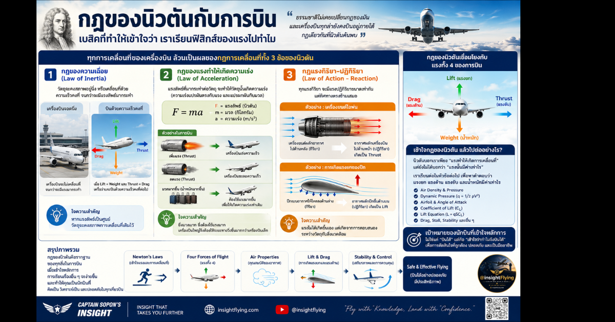
เบสิกที่ทำให้เข้าใจว่า เราเรียนฟิสิกส์ของแรงไปทำไม เมื่อเริ่มเรียนวิชา Principle of Flight หลายคนอาจรู้สึกว่าเนื้อหาเต็มไปด้วยสมการและหลักฟิสิกส์ที่ดูซับซ้อน ทั้ง Lift, Drag, Thrust, Weight, Angle of Attack, Bernoulli’s Principle, Newton’s Laws หรือ Dynamic Pressure คำถามที่มักเกิดขึ้นคือ “นักบินจำเป็นต้องรู้เรื่องพวกนี้จริงหรือ?” คำตอบคือ… จำเป็นมาก เพราะทุกครั้งที่เครื่องบินเคลื่อนที่ ทุกครั้งที่เราดันคันเร่ง ดึงหรือดันคันบังคับ ทุกสิ่งที่เกิดขึ้นล้วนเป็นผลของกฎฟิสิกส์ โดยเฉพาะ กฎการเคลื่อนที่ของเซอร์ไอแซก นิวตัน (Newton’s Laws of Motion) กล่าวได้ว่า หากไม่มี Newton ก็ไม่มีวิชา Principle of Flight อย่างที่เราเรียนกันในปัจจุบัน ก่อนจะเข้าใจ Lift ต้องเข้าใจ “แรง” หลายคนเริ่มเรียนการบินจากการท่องจำว่า แต่แท้จริงแล้ว… แรงทั้งสี่นี้ล้วนปฏิบัติตามกฎของนิวตันทั้งหมด เมื่อเข้าใจ Newton แล้ว…





Pingback:Precipitation / การตกของฝนหรือหิมะ - Insight Flying